CAD/BIM Tips & Tricks
AI-Powered Digital Twins: Transforming DOT Infrastructure Inspections
21 October 2025
While technologies such as digital twins and drones have been around for a while, they’re increasingly being adopted in new ways by Departments of Transport. This article explores how some of these technologies are being combined to improve the accuracy, maintenance and safety of infrastructure in the US.
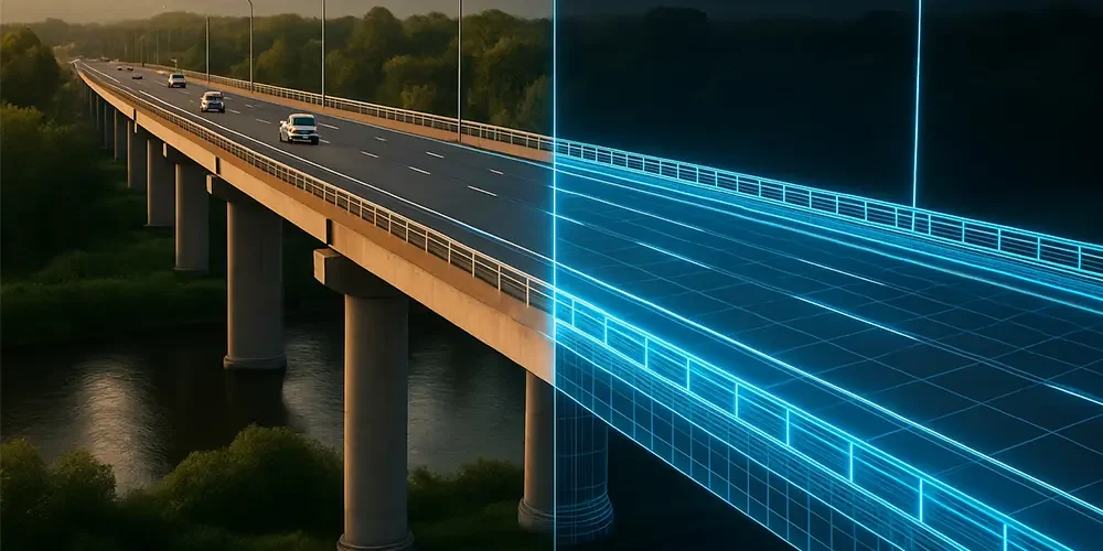
A highway bridge is scanned with LiDAR (Light Detection and Ranging) drones, producing a highly detailed 3D point cloud (a dataset consisting of millions of individual points that represents a specific location in three-dimensional space). Within hours, engineers are comparing the real-world condition of the bridge against the original design models. And they’re discovering things. Cracks, deflections and even small structural shifts are spotted long before they can become costly problems or risky safety issues.
Within hours, engineers are comparing the real-world condition of the bridge against the original design models.
If you saw our article, Bridge Engineers: At the End of Their Rope, you’d be forgiven for thinking that drone inspections sound a bit like science fiction, but they aren’t. It’s happening now as more US Departments of Transportation (DOTs) receive federal funding to cover costs.
In May 2021, the Mississippi Department of Transportation purchased LiDAR drones — becoming one of the first states in the Southeast to use the technology for road projects — and reported improved efficiency and safety. Between 2023 and 2025, more US states implemented the technology, with federal funding becoming available through programs like the Bipartisan Infrastructure Law to encourage the use of LiDAR and other innovative technologies.

With over 42,000 bridges currently rated as “structurally deficient” in the US, anything that allows for faster, more accurate inspections should be enthusiastically embraced.
Across the country, DOTs are also turning to digital twins — virtual replicas of physical structures that integrate real-time data. But this raises its own challenges.
Converting raw reality-capture data into CAD or BIM models is a complex and highly skilled process, not a simple push-button task.
- There is currently no software that can automatically convert raw point cloud data into a complete, intelligent BIM model. Instead, designers have to manually rebuild the architectural and structural elements in a multi-step process.
- Compared to BIM, converting raw point cloud data to CAD is a slightly easier process in which a tech traces or “snaps” to the point cloud to create traditional 2D drawings or simple 3D meshes. This creates a static, geometric representation.
But there’s a catch. The raw data from the drones, scanners and survey tools doesn’t magically turn into neat, usable CAD or BIM models. And that’s where many projects hit a wall.
Join us as we explore how digital twins are now taking center stage in infrastructure, the challenges of converting reality-capture into usable design files and how the right tools can help DOT professionals bridge the gap.
The raw data from the drones, scanners and survey tools doesn’t magically turn into neat, usable CAD or BIM models.
What Exactly is a Digital Twin?
While a traditional 3D model is a static, standalone visual representation of an object or environment used primarily for visualization and design, a digital twin is a living digital model of a physical asset or structure (such as a building, bridge, road, tunnel or dam). A “living” model is a digital twin that is automatically updated to match the current state of the actual physical item in the real world. Digital twins can reside either in the cloud or in on-prem data centers.
Here’s how it works:
1. Real-Time Data Integration

- A live digital twin ingests continuous data streams from IoT sensors, SCADA (Supervisory Control and Data Acquisition) systems, drones or other monitoring technologies on bridges, traffic signals, energy grids and the like. These data sources constantly measure and transmit dynamic data like temperature, vibration, stress, traffic flow, power consumption and environmental conditions.
- The twin integrates this sensor data with other dynamic sources, such as weather feeds, maintenance logs, operational system data and geospatial information (such as LiDAR or satellite imagery).
- For example, a bridge’s digital twin may pull in strain gauge readings, vibration data and environmental conditions so that engineers can see how it’s behaving under live traffic conditions.
2. Dynamic Updates
- Instead of being a snapshot frozen at design or construction, the twin runs continuous analysis and simulations of real-world scenarios, updating as the physical asset changes over time.
- This includes changes during construction, wear and tear, maintenance activities and environmental impacts.
3. Operational Context
- A live twin incorporates operational and performance data — such as energy usage in a building, traffic flow in a highway network or water levels in a stormwater system — so stakeholders can make informed decisions based on up-to-date real-world data.
Drones and ground-based scanners can now gather millions of data points in mere minutes.
4. Predictive and Prescriptive Capabilities
- Because it mirrors live conditions, the twin can run what-if scenarios using Artificial Intelligence (AI), Machine Learning (ML) or simulation engines.
- For example, predicting when a piece of equipment might fail or suggesting optimal maintenance timing to reduce downtime.
5. Bidirectional Feedback
- A fully “live” system is not only fed by the physical world but can also send instructions back to it. For instance, adjusting HVAC systems in a smart building or rerouting traffic dynamically.
- This closes the loop between the virtual and physical.
6. Collaboration & Accessibility

- A live twin can be accessed across stakeholders (owners, operators, engineers, contractors) with different layers of data visibility.
- Cloud connectivity and interoperability make it possible for multiple systems and people to interact with the same up-to-date model.
For DOTs, this means:
- Roadways can be monitored for wear and tear with precision.
- Bridges can be inspected digitally, reducing the need for dangerous manual inspections.
- Transit systems can be modeled in real time, making scheduling, maintenance and upgrades more efficient.
The payoff is huge: Fewer costly surprises, safer infrastructure and smarter use of taxpayer dollars. (Always appreciated!)
What Reality-Capture Means for DOTs
The tools to create digital twins, increasingly AI-assisted, are advancing at lightning speed. Drones and ground-based scanners can now gather millions of data points in mere minutes, producing highly accurate 3D representations of roads, bridges, tunnels and rail lines.
DOTs are particularly excited about reality-capture for:
- Bridge inspections — safer, faster and often more accurate than manual inspections.
- Roadway surveys — capturing exact conditions before, during and after construction.
- Infrastructure asset management — keeping an up-to-date and accurate record of existing infrastructure conditions.
Between the data-gathering phase and the final output is the messy middle.
But while collecting the data is easier than ever, turning that raw information into something useful remains a time-consuming challenge.
The Messy Middle: From Point Clouds to CAD/BIM
Between the data-gathering phase and the final output is the messy middle. Think of it as a peanut butter and jelly sandwich. The bread on either side is perfectly fine, but all the squishy, sticky stuff is in the middle. Anyone who has worked with point cloud data knows the frustration. The scans may be breathtaking in detail, but they’re also:
- Massive in size, making files unwieldy and difficult to share.
- Full of noise, with extra data points, irrelevant details or duplicate geometry.
- Poorly structured, making it tough to align with CAD/BIM standards.
Like wading through peanut butter and jelly, this messy middle is where many DOT teams lose momentum. Engineers end up spending countless hours cleaning up files, fixing references and aligning models before they can even begin analysis.
That’s where CAD and BIM teams may need a helping hand — and where purpose-built tools can make all the difference.
Why a Strong CAD/BIM Backbone Makes or Breaks Digital Twins
For a digital twin to be useful, it must play nicely with existing CAD and BIM workflows. DOT engineers and contractors rely on tools like MicroStation®, AutoCAD® and Revit®. If scan data can’t be easily integrated, the promise of a digital twin falls flat.
For a digital twin to be useful, it must play nicely with existing CAD and BIM workflows.
Reliable workflows mean:
- Consistent standards across projects.
- Accurate references.
- Smaller, more manageable file sizes that don’t bring progress to a halt.
- Error-free models that reduce rework and miscommunication.
In short, a digital twin is only as good as the CAD/BIM backbone it rests on.
Automating Cleanup So Engineers Can Focus on What Matters
Here’s where Axiom’s suite of tools shines. By automating the tedious but critical cleanup tasks, engineers can focus on high-value work instead of file babysitting.
For example:
- Microsoft Office Importer™ produces flawlessly formatted imports of Excel® and Word® data. Available for MicroStation, Revit and AutoCAD.
- FileFixer™ ensures MicroStation models don’t crash mid-project by catching and repairing corruption early.
- RefManager™ keeps MicroStation references properly aligned so that massive infrastructure files stay organized.
- Global File Changer™ makes mass changes in MicroStation quickly, saving time when details shift mid-project.
Think of these tools (and Axiom’s many other time-saving tools for MicroStation, Revit and AutoCAD) as your behind-the-scenes wingmen — helping keep CAD and BIM workflows clean, consistent and reliable.
Beyond the Buzzword: Real Benefits for DOTs
It’s easy to dismiss “digital twin” as just another industry buzzword, but the benefits for DOTs are real and measurable.
Digital twins help agencies:
- Save money by catching problems early.
- Improve safety by reducing the need for risky physical inspections.
A digital twin is only as good as the CAD/BIM backbone it rests on.
- Speed up projects by aligning field and office data faster.
- Ensure accuracy by maintaining one reliable, documented source of truth.
When combined with the right CAD or BIM software, digital twins more easily become a practical tool for today’s infrastructure challenges.
Looking Ahead: The Role of Digital Twins in DOT Work
As digital twin adoption grows, expect to see:
- More mandates: State and federal agencies may soon require digital twins for certain projects.
- Better interoperability: Standards like ISO 19650 (an international standard that provides a framework for managing information in the construction and built asset industry using Building Information Modeling) will help teams collaborate across platforms.
By automating the tedious but critical cleanup tasks, engineers can focus on high-value work instead of file babysitting.
- Integration with AI: Automated detection of cracks, corrosion or design deviations will become mainstream.
- Lifecycle management: From design to construction to maintenance, digital twins will guide decisions every step of the way.
DOTs that get ahead of this trend will be positioned as leaders in infrastructure innovation.
Final Thoughts
Digital twins are transforming how DOTs design, build and maintain infrastructure. But while the promise is huge, the road is not without its challenges — converting raw reality-capture data into usable CAD/BIM models.
The good news? With the right tools, the messy middle becomes more manageable. Engineers spend less time fixing files and more time solving problems — clean hands, if you will, instead of sticky. DOTs can save money, improve safety and deliver better infrastructure for the public.
At the end of the day, digital twins aren’t just about fancy 3D models — they’re about creating smarter, safer and more efficient ways to build and maintain the infrastructure we all depend on.

